Note: Many thanks to Ralph W0RPK for all the work on tracking these circumnavigating amateur radio balloon flights and providing updates to this page. As of the end of 2016, there were still several balloons in the air on multiple laps. The number of long duration balloon projects is increasing all the time. The workload on Ralph became too much. Therefore we have taken the decision not to continue to update this page. Now that the skills and experience has increased and the flights are more common, it is not practical (and perhaps not so useful to readers) to continue to update it ever more frequently! The page remains a testimonial to the pioneering work of the early circumnavigation balloon constructors and operators!
This article documents the amazing achievements of radio amateurs flying small "floater" balloons around the world. A circumnavigation is a complete trip around the world, passing the starting longitude. If the following list of flights is complete or inaccurate please email us!. This list was compiled by Ralph Wallio W0RPK who wrote this article for the QRP Labs website. (NOTE: The pictures are scaled to suit this article format. Please click each map picture for the full-size version).
Introduction by Ralph Wallio W0RPK
My introduction to what came to be known as Amateur Radio High Altitude Ballooning, ARHAB, was from Bill Brown, WB8ELK, and his high altitude ballooning presentation to the 1989 AMSAT Annual Meeting and Space Symposium (hosted by the Central Iowa Technical Society, CITS, in Des Moines, Iowa). Continuing to consider what Bill presented, in 1993 I attended a high altitude ballooning seminar in Denver hosted by EOSS, Edge of Space Sciences, http://www.eoss.org/.
CITS then flew four HABET flights (High Altitude Balloon Experiments in Technology) later in 1993 and during 1994. Then HABET, with the assistance of the Iowa Aerospace Education Council, was moved to Iowa State University in 1995 with funding from the Iowa Space Grant Consortium. HABET continues today in the Aerospace Engineering Department (https://sites.google.com/site/cyhabet/about-us/history).
A few years later, while hosting and maintaining ARHAB web pages, an unintended floater captured my attention. On January 8, 2000 Pete Sias, WB0DRL, launched a Sky Science Over Kansas (SSOK) high altitude balloon mission from Salina, Kansas. See http://showcase.netins.net/web/wallio/SSOK.html for the result when Pete's latex balloon refused to burst creating a 700-mile track.
Today, 16-years later, I continue to closely follow and kibitz about floating ARHAB flights. There are several Hams applying ingenious balloon lift, payload weight and telemetry schemes with increasing flight times and track lengths. Collective improvements in state-of-the-art has resulted in multiple circumnavigating flights (in date-of-launch order):
| Callsign | Flight | Date | Comments |
| M0XER | B-63 | 08-Jul-2014 | |
| M0XER | B-64 | 12-Jul-2014 | 8 circumnavigations |
| M0XER | B-66 | 15-Jul-2014 | 3 circumnavigations |
| K6RPT | CNSP-21 | 25-Jan-2015 | |
| VK3YT | PS-41 | 05-Apr-2015 | |
| K6RPT | CNSP-24 | 12-Apr-2015 | |
| VK3YT | PS-46 | 22-May-2015 | 2 circumnaviations |
| M0SBU | UBSEDS15 | 30-Apr-2016 | Also used callsign AD6AM |
| K6RPT | CNSP-29 | 13-Jun-2016 | 3 circumnavigations |
| VE3KCL | S-11 | 14-Jun-2016 | First QRP Labs powered balloon circumnavigation! |
| M0SBU | UBSEDS18 | 17-Aug-2016 | 5 circumnavigations; also uses callsign AD6AM-12 |
| W7QO | HIRF(W)-3 | 22-Aug-2016 | 3 circumnavigations |
| K6RPT | CNSP-30 | 25-Aug-2016 | 3 circumnavigations |
| W7QO | HIRF(W)-5 | 08-Sep-2016 | 2 circumnavigations |
| W7QO | HIRF(W)-6 | 20-Sep-2016 | 6 circumnavigations |
| VE3KCL | S-18 | 07-Oct-2016 | Second QRP Labs powered balloon circumnavigation! |
| KD2EAT | Wisp1c_12 | 19-Oct-2016 | Landed in FN44be after completing circumnavigation lap |
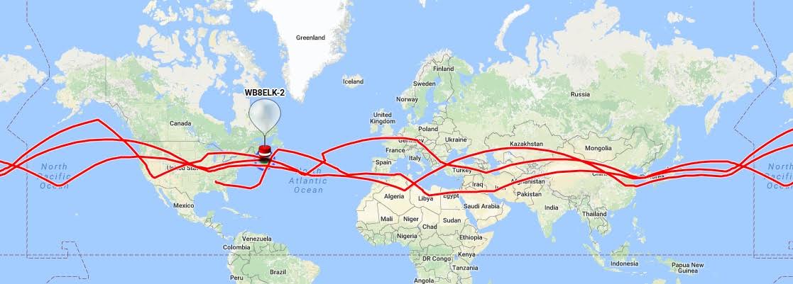
| WB8ELK | WB8ELK-2 | 17-Nov-2016 | 3 circumnavigations |
| M0SBU | UBSEDS21 | 11-Dec-2016 | Also uses callsign AD6AM-13 |
Following is a compilation of all known circumnavigating ARHAB flights which includes information contained in flight web pages and in telemetry archives (principally http://habitat.habhub.org/ and then http://habitat.habhub.org/ept/). Flights are listed in chronological order of launch dates. Please see given web pages for much more information including payload details.
de Ralph Wallio W0RPK
http://showcase.netins.net/web/wallio/
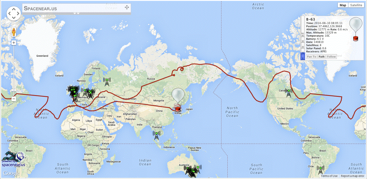
M0XER B-63
FLIGHT LAUNCH: DATE/TIME/LAT/LONG CIRCUMNAVIGATION: DATE/TIME/LAT/LONG FLT ALT INTERVAL
-------- ------------------------------
B-63 08Jul14/06:53z/52.0958/-1.0214 06Aug14/04:57z/42.3912/-1.0149 13200m 29-days
M0XER-3
Contestia 64/1000 434.500MHz USB LAST TELEMETRY: DATE/TIME/LAT/LONG/ALT
2m APRS on regional frequencies ------------------------------
10mW transmitter
http://leobodnar.com/balloons/
MOXER B-64
FLIGHT LAUNCH: DATE/TIME/LAT/LONG CIRCUMNAVIGATION: DATE/TIME/LAT/LONG FLT ALT INTERVAL
-------- ------------------------------
B-64 12Jul14/06:59z/52.0958/-1.
M0XER-4
Contestia 64/1000 434.500MHz USB [#3] 07Sep14/16:00z/78.2631/-1.
2m APRS on regional frequencies [#4] 20Sep14/16:00z/72.2628/-1.2322 11900m 13-days
10mW transmitter
------------------------------
http://leobodnar.com/balloons/
M0XER B-66
FLIGHT LAUNCH: DATE/TIME/LAT/LONG CIRCUMNAVIGATION: DATE/TIME/LAT/LONG FLT ALT INTERVAL
-------- ------------------------------
B-66 15Jul14/14:17z/52.0958/-1.
M0XER-6
Contestia 64/1000 434.500MHz USB [#3] ~08Sep14/unk/unk/unk
2m APRS on regional frequencies
10mW transmitter
"Most of the last lap data is missing due to failing battery. B-66 stopped transmitting over
Russia and appeared again over Atlantic near Ireland having traveled East. The track maps show
this segment replaced with shortest path which might look confusing as it is "on the other side
of the world." [de Leo M0XER]
http://leobodnar.com/balloons/

K6RPT CNSP-21
FLIGHT LAUNCH: DATE/TIME/LAT/LONG CIRCUMNAVIGATION: DATE/TIME/LAT/LONG FLT ALT INTERVAL
-------- ------------------------------
CNSP-21 25Jan15/unk/unk/unk
K6RPT-12
2m APRS on regional frequencies LAST TELEMETRY: DATE/TIME/LAT/LONG/ALT
------------------------------
11Feb15/unk/unk/unk/unk (Morocco)
http://www.cnsp-inc.com/cnsp-
CNSP-21 crossing US and Atlantic for the second time:
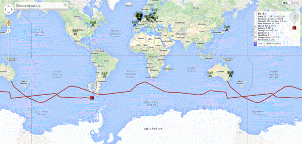
VK3YT PS-41
FLIGHT LAUNCH: DATE/TIME/LAT/LONG CIRCUMNAVIGATION: DATE/TIME/LAT/LONG FLT ALT INTERVAL
-------- ------------------------------
PS-41 05Apr15/unk/~-37.8/144.903 16Apr15/01:00z/-54.455/144.947 ~9000m 11-days
VK3YT
20m/30m WSPR/JT9 telemetry LAST TELEMETRY: DATE/TIME/LAT/LONG/ALT
25mW transmitter
http://picospace.net/?m=201504
K6RPT CNSP-24
FLIGHT LAUNCH: DATE/TIME/LAT/LONG CIRCUMNAVIGATION: DATE/TIME/LAT/LONG FLT ALT INTERVAL
-------- ------------------------------
CNSP-24 12Apr15/unk/unk/unk
K6RPT-11
2m APRS on regional frequencies LAST TELEMETRY: DATE/TIME/LAT/LONG/ALT
http://www.cnsp-inc.com/cnsp-
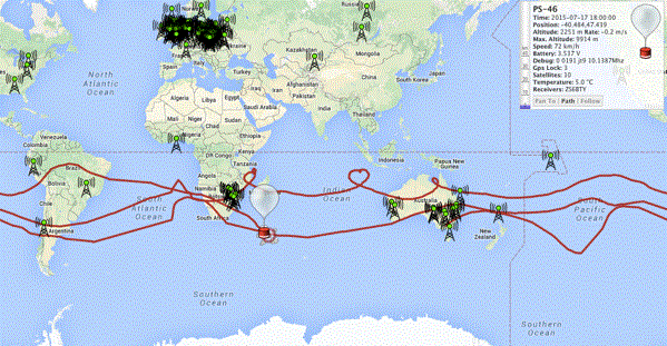
VK3YT PS-46
FLIGHT LAUNCH: DATE/TIME/LAT/LONG CIRCUMNAVIGATION: DATE/TIME/LAT/LONG FLT ALT INTERVAL
-------- ------------------------------
PS-46 22May15/21:00z/~-37.8/144.894 [#1] 04Jun15/01:00z/-27.834/145.37 ~9000m 13-days
VK3YT [#2] 04Jul15/02:30z/-19.135/145.234 ~9000m 30-days
20m/30m WSPR/JT9 telemetry
25mW transmitter
http://picospace.net/?m=201505
M0SBU UBSEDS15
FLIGHT LAUNCH: DATE/TIME/LAT/LONG CIRCUMNAVIGATION: DATE/TIME/LAT/LONG FLT ALT INTERVAL
-------- ------------------------------
UBSEDS15 30Apr16/08:09z/51.4668/-2.5803 01Jun16/10:14z/69.603348/-2.
M0SBU-11
AD6AM-11
Contestia 16/1000 434.600MHz USB +6dBm ------------------------------
2m APRS on regional frequencies +14dBm 16Jun16/13:10z/71.409423/9.
http://www.bristol-seds.co.uk/

K6RPT CNSP-29
FLIGHT LAUNCH: DATE/TIME/LAT/LONG CIRCUMNAVIGATION: DATE/TIME/LAT/LONG FLT ALT INTERVAL
-------- ------------------------------
CNSP-29 13Jun16/14:14z/37.24/-121.8
K6RPT-12
2m APRS on regional frequencies LAST TELEMETRY: DATE/TIME/LAT/LONG/ALT
http://www.cnsp-inc.com/cnsp-
https://tracker.habhub.org/#!

VE3KCL S-11
FLIGHT LAUNCH: DATE/TIME/LAT/LONG CIRCUMNAVIGATION: DATE/TIME/LAT/LONG FLT ALT INTERVAL
-------- ------------------------------
S-11 14Jun16/10:06z/43.729/-79.375
VE3KCL
20m/30m WSPR/JT9 telemetry LAST TELEMETRY: DATE/TIME/LAT/LONG/ALT
GPS problems above 10,000m 08Jul16/09:18z/62.6458/48.625/
http://www.qrp-labs.com/
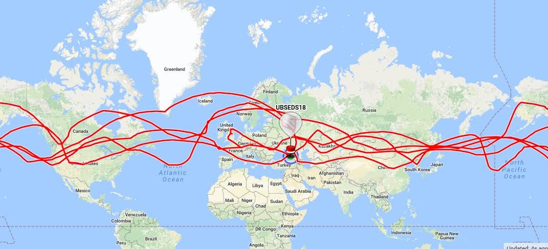
M0SBU UBSEDS18
FLIGHT LAUNCH: DATE/TIME/LAT/LONG CIRCUMNAVIGATION: DATE/TIME/LAT/LONG FLT ALT INTERVAL
-------- ------------------------------
UBSEDS18 17Aug16/07:08z/51.4658/-2.
M0SBU-12
AD6AM-12
Contestia 16/1000 434.612.5MHz USB ------------------------------
2m APRS on regional frequencies Aloft on 06Nov16 at 12829m over Black Sea
http://www.bristol-seds.co.uk/
https://twitter.com/
https://tracker.habhub.org/#!
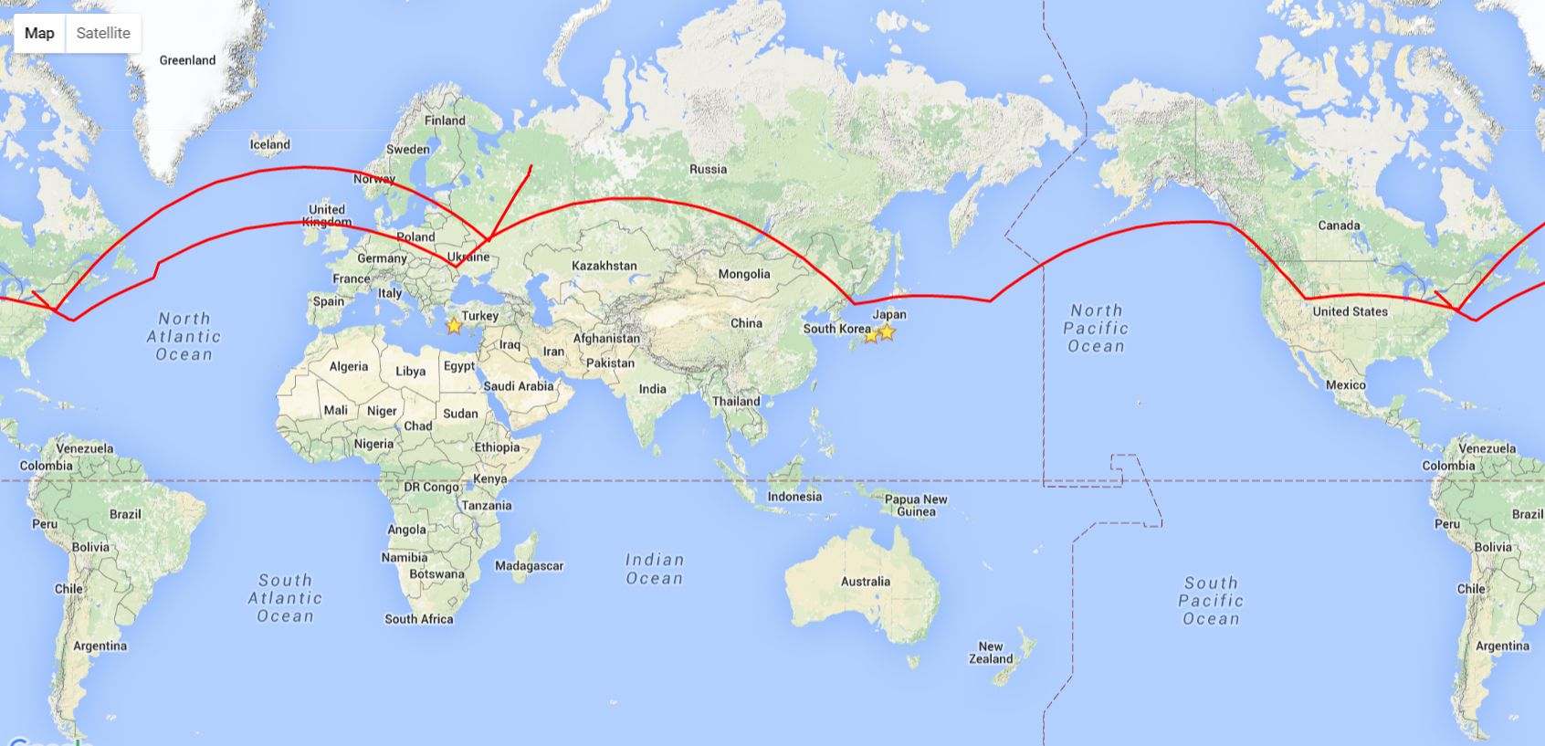
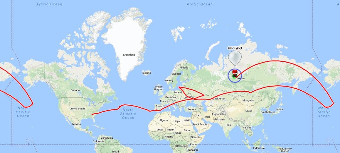
W7QO HIRF(W)-3
This balloon flight has 21 days of missing data but probably completed a circumnavigation. The back-track on the map path below should actually contain a complete lap of the Earth, but due to problems the position wasn't reported during this time. Alan W7QO comments:
" ... cold temp startup issue, sometimes they start up, sometimes (most) they don't." and " ... due to a mistake on my part, I forgot to start the script that takes the WSPR call and pushing it to APRS after I had done some other work on the script."
FLIGHT LAUNCH: DATE/TIME/LAT/LONG CIRCUMNAVIGATION: DATE/TIME/LAT/LONG FLT ALT INTERVAL
-------- ------------------------------
HIRFW-3 22Aug16/~10:00z/34.022/-83.
HIRF-3 (APRS)
K4MEA (WSPR)
2m APRS on regional frequencies LAST TELEMETRY: DATE/TIME/LAT/LONG/ALT
WSPR-based telemetry
https://tracker.habhub.org/#!
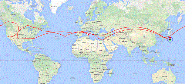
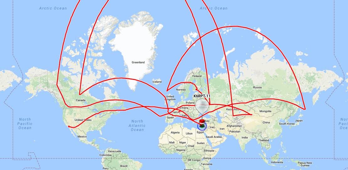
K6RPT CNSP-30
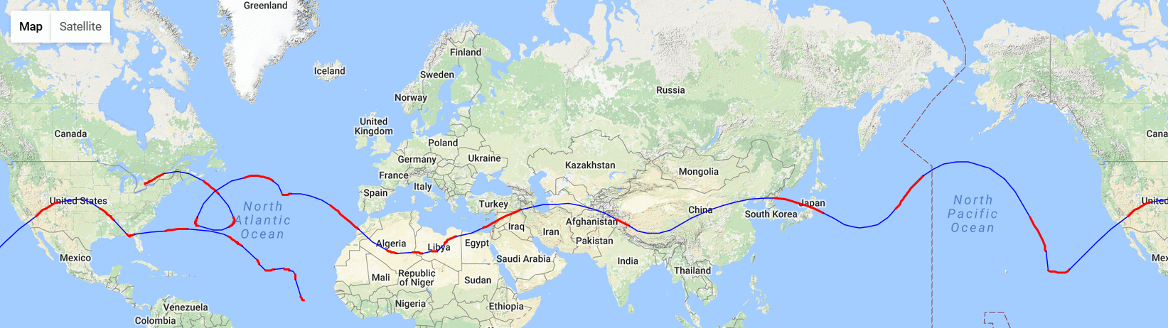
The strange shape of the map is explained by the last APRS reports of the balloon being north-east of Japan, then nothing at all over North America, until the balloon reached Europe again. So there are no APRS reports around the launch longitude but the balloon did pass it. This happened a second time with the 2nd circumnavigation.
FLIGHT LAUNCH: DATE/TIME/LAT/LONG CIRCUMNAVIGATION: DATE/TIME/LAT/LONG FLT ALT INTERVAL
-------- ------------------------------
CNSP-30 25Aug16/UNK/37.24/-121.8
K6RPT-11
2m APRS on regional frequencies LAST TELEMETRY: DATE/TIME/LAT/LONG/ALT
http://www.cnsp-inc.com/cnsp-
https://tracker.habhub.org/#!
W7QO HIRF(W)-5
FLIGHT LAUNCH: DATE/TIME/LAT/LONG CIRCUMNAVIGATION: DATE/TIME/LAT/LONG FLT ALT INTERVAL
-------- ------------------------------
HIRFW-5 08Sep16/~10:00z/33.981/-83.
HIRF-5 (APRS} [#2] 13Oct16/12:20z/28.7727/-83.
W7QO (WSPR)
2m APRS on regional frequencies LAST TELEMETRY: DATE/TIME/LAT/LONG/ALT
WSPR-based telemetry
https://tracker.habhub.org/#!

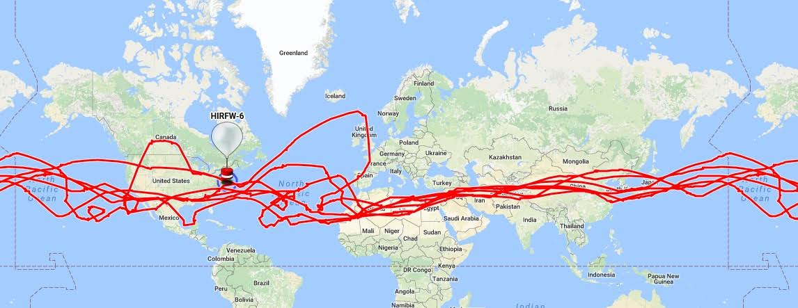
W7QO HIRF(W)-6
FLIGHT LAUNCH: DATE/TIME/LAT/LONG CIRCUMNAVIGATION: DATE/TIME/LAT/LONG FLT ALT INTERVAL
-------- ------------------------------
HIRFW-6 20Sep16/10:05z/33.9394/-83.
HIRF-6 (APRS}
K4JCW (WSPR)
[#6] 23Dec16/13:51z/41.4810/-81.
2m APRS on regional frequencies LAST TELEMETRY: DATE/TIME/LAT/LONG/ALT
WSPR-based telemetry
https://tracker.habhub.org/#!
VE3KCL S-18
FLIGHT LAUNCH: DATE/TIME/LAT/LONG CIRCUMNAVIGATION: DATE/TIME/LAT/LONG FLT ALT INTERVAL
-------- ------------------------------
S-18 06Oct16/01:18z/43.6875/-79.
VE3OCL
20m/30m WSPR/JT9 telemetry LAST TELEMETRY: DATE/TIME/LAT/LONG/ALT
27Oct16/16:46z/32.0625/-69.
http://qrp-labs.com/flights/
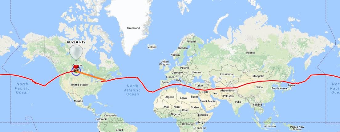
KD2EAT Wisp1c_12
FLIGHT LAUNCH: DATE/TIME/LAT/LONG CIRCUMNAVIGATION: DATE/TIME/LAT/LONG FLT ALT INTERVAL
--------- ------------------------------
Wisp1c_12 19Oct16/16:58z/42.3560/-76.
KD2EAT-12
WSPR-based telemetry LAST TELEMETRY: DATE/TIME/LAT/LONG/ALT
------------------------------
http://hojoham.blogspot.com/
WB8ELK WB8ELK-2
FLIGHT LAUNCH: DATE/TIME/LAT/LONG CIRCUMNAVIGATION: DATE/TIME/LAT/LONG FLT ALT INTERVAL
--------- ------------------------------
WB8ELK 17Nov16/12:30z/34.4083/-86.
WB8ELK-2
WSPR-based telemetry
https://tracker.habhub.org/#!
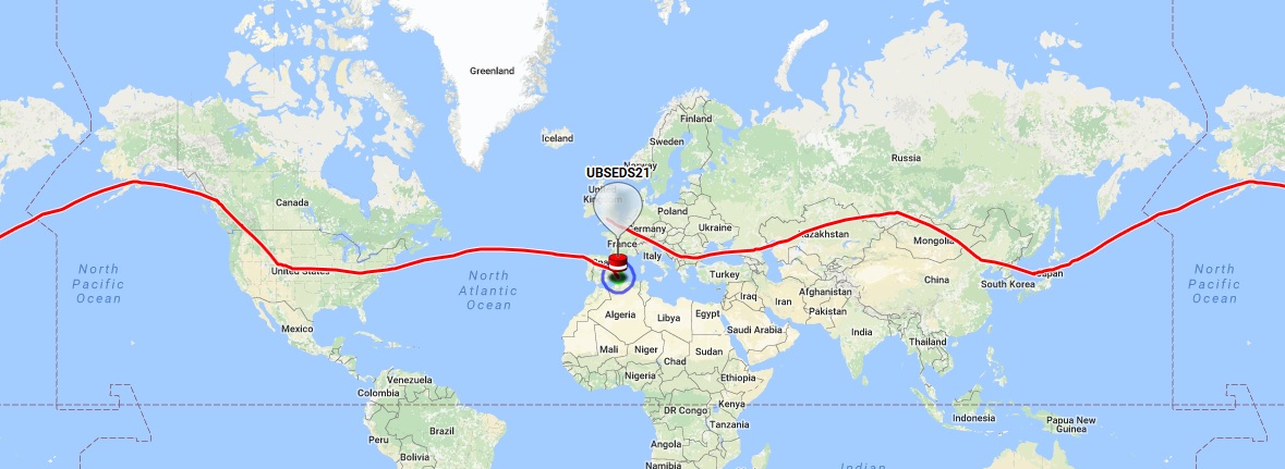
M0SBU UBSEDS21
FLIGHT LAUNCH: DATE/TIME/LAT/LONG CIRCUMNAVIGATION: DATE/TIME/LAT/LONG FLT ALT INTERVAL
-------- ------------------------------
UBSEDS21 11Dec16/05:23z/51.4676/-2.5784 23-24Dec16/UNK/39.9543/-0.
M0SBU-13
AD6AM-13
Contestia 16/1000 434.610MHz USB ------------------------------
2m APRS on regional frequencies Aloft on 24Dec16 at 15463m over Med
APRS on 145.825
http://www.bristol-seds.co.uk/
https://twitter.com/
https://tracker.habhub.org/#!