Skip to TRACKING section below!
On Sunday 04-May-2025 QRP Labs was honored to host some visitors from Mugla Deneyap (technology workshop) and Mugla university, several undergraduate and postgraduate students as well as Professor Baris of the Computer Engineering Department at Mugla university. We showed them the QRP Labs offices and explained about amateur radio and all the QRP Labs products. Except for Necati TA7MNA, none of the other visitors were radio amateurs. There were many questions and a lot of interesting conversation for many hours.
Our activity for the visit was to prepare and launch two U4B balloon trackers, which we are calling Deneyap-1 and Deneyap-2. Why two? Because balloon tracker construction and launching is a difficult thing, there are many possible paths to failure and not nearly so many paths to success. So with two, we ought to double our chances of success...


Skip to TRACKING section below!
Tracker construction
Both trackers are built exactly the same. The solar panels are 38 x 19mm and only about 0.2mm thick glass, they are extremely fragile. At the same time the amount of mateirals should be minimized in order to avoid increasing the payload weight. Previously I had noted that polystyrene and glue are not best friends, the glue melts the polystyrene... so this time the payload was assembled using a thin (5mm or so) slice of polystyrene foam, half of each cell sits on the foam, and some thin string ties it all together. With that and the 0.33mm diameter enamelled copper wires connecting the panels in series, you have a stable (but very fragile) configuration. The U4B itself sits under the foam, held in place by the thin strings.
Connections are very simple:
- 1575 MHz antenna for reception of GPS satellites (made from some pieces of 0.33mm diameter wire)
- HF antenna is a full size dipole consisting of two 5.1m legs (see below)
- Solar panel + and - are connected to the "SOLAR" and "GND" and there's no battery connection.
The USB connector was broken off to save (a lot of) weight. There's no battery connected in this flight.

Six panels in series in direct sunlight can produce about 3.3V at 200mA (more than sufficient current for the U4B which needs less than 40mA). There is no battery onboard so these trackers only operate in daytime when the solar angle is sufficient for the flat solar panels to provide sufficient power.


Antenna construction
The GPS antenna (1575 MHz) is a dipole with legs measuring about 46mm, and about 30mm of tightly twisted 0.3mm enamelled copper wire as the "feedline". It resembles a T shape and pokes up through the foam above the solar panels.
The main HF antenna is cut for 14 MHz (20m band) and each leg is 5.1m. We used very thin wire from a reed relay coil. On my micrometer it measured 0.06mm diameter. It's very fragile wire. We stretched out 5.1m of thin string and unwound the wire, twisting it helically around the string a few time to run them together, but with the wire not pulled very tight; then dabbed a small blob of superglue every 30cm or so (Superglue is also known as Krazy glue in USA or Cyanoacrylate glue, CA glue, or in Turkey, Japon glue).
It was difficult to solder these tiny wires and tie the string onto the trackers. We wound the antennas around paper rolls to prevent them tangling up. Eventually everything was ready!


Tracker configuration
Deneyap-1: Callsign G0UPL (Hans), Channel 514. Transmission frequency is 14,097,140 and the telemetry packet callsign format is QX5XXX, with transmissions starting at minute 06 in each 10-minute cycle.
Deneyap-2: Callsign TA7MNA (Necati), Channel 538. Transmission frequency is 14,097,180 and the telemetry packet callsign format is QX6XXX, with transmissions starting at minute 04 in each 10-minute cycle.
Both trackers are running an identical program:
LET C = 0
LET HP = 0
10 GPS 360
CW 0 14098210 5 0 "*01IFLCNAO9P8Q7R6R6R6R6Q7Q7P8HGEHJFEGH*"
IF HP = 1
    CW 0 14096985 1 0 "T"
ELSE
    CW 0 14096950 1 0 "T"
ENDIF
TELE
LET C = C + 1
IF C = 5
    LET HP = 1
ENDIF
GOTO 10

The tracker starts off in the early morning in low power mode (about 9 mW) and switches to high power mode (about 27 mW) for the 6th transmission. As this is almost an hour later, it is hoped that the higher solar angle will provide more power for the transmission.
The fourth line transmits a pattern generated by transmitting a carrier for 1 second on a sequence of frequency shifts defined by the string of letters (refer to U4B documentation for details). On audio spectrum analyzer software such as Argo running on a PC at receiving stations, the sequence of frequency shifts traces out a pattern, one pixel at a time. The pattern was designed to resemble a little Turkish flag!
In the rightmost image below you can see the results receiving a sequence of these glyphs on a local radio receiver (QMX+). In actual operation the glyph is transmitted once per 10 minute program cycle (after the GPS satellite acquisition). Note that there is a little dash after the glyph which is at a lower frequency if the tracker is in low power mode, and a higher frequency if the tracker is in high power mode.


Launch
By the time we finished preparing the trackers and antennas, and without even having time to test them, it was nearly sunset. XYL managed to convince the gas supply shop at the local industrial estate (about 15 minutes by car) to come to his store on a Sunday and sell us some Helium. As we waited a few minutes for the gas man to arrive, the sun disappeared on the Western horizon behind the mountains.
The balloon payloads ended up weighing just under 6 grams each, including the solar panels, U4B itself, construction materials and the two 5.1m antenna legs. 6 grams of free lift per balloon were added.
Deneyap-1 (callsign G0UPL) has one balloon.
Deneyap-2 (callsign TA7MNA) has two balloons.
By the time we got home with the balloons and heat-sealed the necks of the balloons, it was already pitch black. It was pointless to think of driving to the beach which already would have closed, or stopping somewhere in the wide open river estuary to try a launch. The stiff sea breeze of the day had disappeared, there didn't seem to be any wind at all. So we took it to the "stadium", a football field which has seating on one side and should be a large enough area. We parked the car and positioned it so that the headlamps shone out across the field.
One antenna wire on Deneyap-1 broke about half way up. That 0.06mm wire was so fragile and it got stuck to the paper tubes, with the superglue. With no chance to repair it, we sent Deneyap-1 off first, followed 10 minutes later by Deneyap-2. Both balloons rose into the starlit night sky without further incident. Of course being dark, we would have no news of the balloon's success until the following morning when sunshine powered the solar panels - if any transmissions were received, it is success, otherwise, a failure due to unknown causes (too much rush, too little testing, too much rush, more rush, etc).
In the event both balloons reported positions the following morning (Monday 05-May-2025) near Suez, Egypt. They had crossed the Mediterranean sea overnight from the launch site in SW Turkey. Deneyap-1 with it's upper antenna broken half way up, is clearly struggling to get many successful reception reports. At least there are some and it's up there working!


Tracking
The balloons can be tracked in the following ways. Note that the tracking map pages don't always work perfectly nicely.
WSPR standard packet reports (most reliable). These are just a table of reception reports of the standard WSPR packet:
Deneyap-1: https://www.wsprnet.org/olddb?mode=html&band=20&limit=5000&findcall=G0UPL&findreporter=&sort=date
Deneyap-2: https://www.wsprnet.org/olddb?mode=html&band=20&limit=5000&findcall=TA7MNA&findreporter=&sort=date
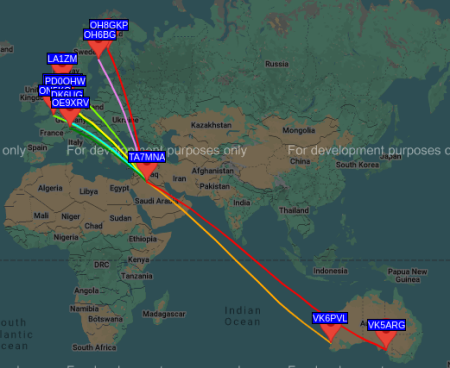
WSPR-map (also very reliable): The WSPR-net website map (example right) shows only the latest position and the map locations of stations which have received the balloon. You have to fill in the details for the map you want, for example:
Band: 20m
Call: TA7MNA
Time period: Last 30 minutes
then click the "Update" button to get the map. Note that the position is as at the start of the period not the end. If you see no map, it could be that you are checking during the balloon's night when it is not transmitting; choose a longer time period to include a time when the balloon was transmitting.
QRP Labs tracking page:
Deneyap-1: https://qrp-labs.com/track/1_Deneyap-1.html
Deneyap-2: https://qrp-labs.com/track/1_Deneyap-2.html
Traquito tracking website: Very well presented tracking page which also graphs the telemetry (altitude, speed, voltage, temperature) but does depend on the WSPR.live website being available and providing the database extract.
Deneyap-1: Click here
Deneyap-2: Click here
Note: as at time of writing, WSPR-live is down, so the Traquito website isn't working.