David VE3KCL launched his third balloon flight S-3 on 28-Jul-2015 at about 11:40Z. Like the former S-2 flight, this one also uses a special U3 firmware version on an Arduino Nano board, with QRP Labs Si5351A Synthesiser. Two foil "party" balloons were used, filled with hydrogen. The earlier balloons S-1 and S-2 apparently suffered burst failure before reaching float altitude due to polluted gas mix - there was a lot of propane mixed in with the hydrogen. This flight S-3 successfully climbed to almost 8,000m so this problem is now solved.
The transmission schedule includes CW on several different bands (for the reverse CW network), 30m JT9 and a special WSPR message on 30m. The special WSPR message types encodes two additional WSPR messages which contain the additional 5th and 6th character of the locator, altitude, battery voltage, temperature, ground speed, GPS status, and number of GPS satellites (a single bit, 0 means under 8, and 1 means 8 or more). The "special" WSPR transmissions therefore show up in the WSPR database with locators and powers which are not the actual locator and power, but encode the additional data. The conversion back to actual flight data is done later in an Excel spreadsheet. This is very experimental at the moment.
Status 04-Aug-2015 0200Z
No signals have been received from the S-3 balloon since 02-Aug-2015 22:45:52. There might be some hope of a propagation anomaly meaning the signals from the centre of the Atlantic could not be heard in the operating window yesterday. Or, there may be damage to the wire antenna that limits its efficiency to much shorter ranges. Perhaps S-3 will get in contact again when it reaches land. But we have to face the more probable reality, that it may have taken a swim in the Atlantic ocean. Either way, it was a fantastic, exciting, educational flight!
Status 03-Aug-2015 0100Z
Slow progress today East over the Atlantic, in light winds. The distance travelled estimate shows 544km covered in the last 24 hours.


Special thanks to Vern VE1VDM for sending an extensive JT9 log. Vern also provided WSPR spots during the middle of the balloon's "day", well after propagation had stopped for any other Canadian/American stations and before the 30m propagation had opened to Europe. For quite a while Vern was the only station providing tracking reports for the balloon.
Another special mention goes to Bob ZL1RS. Bob has established his own "personal best" in receiving the 20mW from the balloon (actually only 16mW measured by Dave VE3KCL). The images below from Bob show the short path reception on the map, and a WSPR screenshot of what Bob suspects is long path reception. If so, that would be a path of 23,500km, quite amazing for the 16mW RF from the S-3 balloon! At the same time, ZL2ABN was also getting spots - Bob says ZL2ABN is on the coast facing West, and his East (short path) direction is into a range of high hills (1000m high, 5km away). That also suggests to long path propagation. Bob ZL1RS hopes to be able to prove the long path reception soon, using his 2nd Beverage antenna pointed at the balloon; the signal strength reception between that and the 1st Beverage "pointed" at the Short Path should be able to prove the long-path theory. Fascinating!


Status 02-Aug-2015 0000Z
The S-3 balloon continued East across the Atlantic, traveling approx 1,200km since yesterday's update. Flight tme is now 4.5 days and total distance approx 3,800km. Lots of WSPR reports received, including many from Joe K1JT. Vernon VE1VDM sent huge JT9 logs as well as contributing many WSPR spots at a time when propagation didn't favour any other stations. Thanks all!


Status 01-Aug-2015 0000Z
S-3 woke up and continued reliable telemetry throughout the daylight hours. The balloon sped up today in higher winds and continued traveling East across the Atlantic at around 8,000m. The balloon flight has now lasted over 3.5 days and the approximate distance traveled is 2,600km. The flight duration and total distance estimate have been added to the flight data in the "Current Position" section above.


Status 31-Jul-2015 0200Z
The balloon woke up some time after sunset and had an uneventful, slow day - cruising Eastwards across the Atlantic. Winds were rather light and are predicted to be higher tomorrow. A large number of WSPRnet reports continued to be received enabling almost perfect decode of the telemetry from every transmission (12 minute cycle). Lots of JT9 telemetry logs were sent by Jim W3BH also, to help fill in any gaps in the WSPR telemetry - but there are no significant gaps! WSPR rocks!


Status 30-Jul-2015 0030Z
At sunrise in the Eastern US, the S-3 balloon began to heat up and charge its battery via the solar cell. Sometime around 1100Z the system started itself up and began transmitting data packets via WSPRnet. The straight line path from the Canada/US border to Philadelphia represents the balloons path during the night, when position reports were not received.
The balloon passed through stormy weather just off the Eastern US coast as it started its journey over the Atlantic. Weather data at the time shows many storms in the area, some of which extended up to (and above) the altitude of the S-3 balloon. You can see some very rapid disturbances in the altitude, ground speed, and position (map path) at this time. But the balloon appears to have survived the experience.
Click images below for larger versions.


JT9 telemetry of the flight was sent in by Mike N8OOU and his JT9 screenshot is above right. The JT9 data shows the full latitude and longitude directly as received from the GPS data string. It also shows (rightmost three numbers) the 10-bit battery and temperature readings, these are the direct values from the microcontroller's analgoue to digital conversion. It is the first time Mike has used JT9. He uses a Kenwood TS-480 and 5-band trap vertical. Mike later sent a full JT9 log which included several more S-3 balloon decodes.
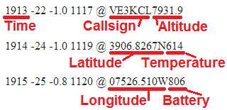
Jim W3BH also sent JT9 telemetry, see below. The red labels added to his screenshot show how to interpret the JT9 data.
Status 29-Jul-2015 0020Z
Balloon climbed smoothly to almost 8,000m altitude. After sunset the battery voltage dropped and at 0020Z the last transmission was received from the balloon. Hopefully the balloon makes it through the night, and wakes up in the morning to tell us where it is. The balloon crossed the Canadian/US border and is now over New York state. Click images below for the full-size versions, showing the data telemetry graphs and the balloon path.


Telemetry
The transmission schedule for the flight is based on a 12 minute transmission cycle, commencing on the hour and repeating every 12 minutes:
0:00 CW ID, and 22wpm CW on 30m, 20m and 17m bands
0:01 JT9 on 10,139,800: "#CS#AT" (callsign, altitude)
0:02 JT9 on 10,139,800: "#LT#A0" (latitude, temperature on analogue A0)
0:03 JT9 on 10,139,800: "#LN#A3" (longitude, battery on analogue A3)
0:04 WSPR on 10,140,150 (standard WSPR transmission)
0:06 WSPR on 10,140,150 with special type #1
0:08 WSPR on 10,140,150 with special type #2
0:10 22wpm CW on 15m, 10m and 6m bands
0:11 Calibration
0:12 Repeat...
Special WSPR type #1 encodes 5th and 6th Maidenhead locator, and altitude into the message; type #2 encodes temperature, battery voltage, ground speed, GPS status and Satellite coverage.
Example, WSPR reports at 13:52Z, 13:54Z and 13:56Z are:
13:52 VE3KCL FN05 13 (normal WSPR)
13:54 VE3KCL DN55 43 (special type #1)
13:56 VE3KCL MP87 20 (special type #2)
This telemetry decodes to:
| Callsign | VE3KCL | |
| Power | +20dBm | |
| Locator | FN05FA | |
| Altitude | 3960m | |
| Temperature | 14C | |
| Battery | 4.1V | |
| Groundspeed | 30m/s | |
| GPS | Ok | |
| Satellites | >= 8 |
The JT9 also contains some of the same data but receive station network coverage is likely to be less comprehensive. The advantage of the WSPR telemetry is that there is an existing vast network of WSPR receiving stations, automatically receiving and loging the data. The CW on multiple bands is such that it could be decoded by the reverse CW network i.e. "TEST TEST DE VE3KCL VE3KCL".
Photos
These photos from Dave VE3KCL show mission control, and one of the balloons being inflated. The photograph of the streetlamp actually shows the two foil balloons in the background, they are suspended one above the other. They have already ascended some distance by this point. Intentions to take more photographs during the launch were thwarted by some last minute panic involving trees and antennas...


